
AN/FPS-19 Early-Warning Radar
Built to watch the northern air approaches with a small crew, the AN/FPS-19 placed two search-radar channels on one rotating antenna assembly. It became a defining sensor of the Distant Early Warning Line and its Aleutian extension.
- Role
- Fixed, long-range aircraft early-warning radar.
- Manufacturer
- Raytheon, following MIT Lincoln Laboratory's experimental development.
- Operating band
- 1220 to 1350 MHz, L-band.
- Antenna
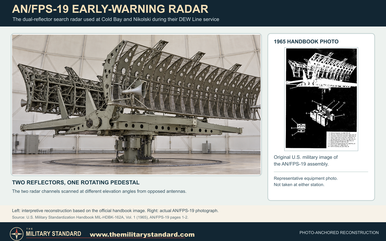
- Two opposed reflectors on one rotating pedestal, one radar channel for each reflector.
- Early deployment
- Prototype tested in Alaska by 1954; original DEW Line operational in 1957.
Overview
The AN/FPS-19 was an American fixed-site search radar designed for the Distant Early Warning Line. Its mission was to give the United States and Canada warning of aircraft approaching across the Arctic, allowing time to alert air-defense forces farther south. Unlike an interceptor-control radar, the FPS-19's principal job was to find aircraft at long distance and pass warning through the larger network. It could not detect an intercontinental ballistic missile in flight. [1] [3]
The radar is sometimes hidden in site photographs by a protective white radome. When exposed, its distinctive feature is a pair of broad reflectors facing in opposite directions on the same revolving structure. Each reflector served a separate radar channel. The nearby White Alice tropospheric-scatter billboards at some Alaskan stations were communications equipment, not parts of the FPS-19. [2] [3]
Development for the Arctic
In 1952, an MIT summer study identified a serious gap in North American warning against Soviet bombers approaching over the polar region. A chain of isolated Arctic stations required a radar that could operate through harsh weather without the large crews typical of earlier air-defense posts. MIT Lincoln Laboratory developed experimental radars in the X series and transferred the X-3 design to Raytheon for production as the AN/FPS-19. Bell Telephone Laboratories contributed antenna development, while Western Electric helped turn the radar into a working line of stations. [1] [3]
Alaska provided the proving ground. Work on the Barter Island experimental DEW installation began in 1953, and an AN/FPS-19 prototype was installed and tested there in 1954. The tests connected radar performance to practical Arctic questions: how to protect a large rotating antenna, maintain the electronics at a remote outpost and transmit warning to the rest of the air-defense system. The original DEW Line was declared operational on July 31, 1957. [3] [4]
Two Radars on One Pedestal
The 1965 military equipment handbook describes the FPS-19 as two radars operating simultaneously on a single pedestal. Each radar fed one of two back-to-back reflectors. The assembly revolved in azimuth, sweeping the surrounding horizon as the reflector pair turned. A channel could be operated in normal search mode or with moving-target indication, which helped separate moving aircraft from stationary ground returns. [2]
In the handbook configuration, the antenna assembly measured 36 feet wide and nine feet high. The normal reflector settings were 2 degrees for the lower beam and 6.5 degrees for the upper beam. Published rotation choices were 3.3, 5, 6.6 and 10 revolutions per minute. Those figures describe the documented equipment configuration; the mission and local conditions determined how a station used it. [2]
A rigid radome could shelter the moving antenna from Arctic wind and ice. The protective dome was neither the radar reflector nor a White Alice antenna. It permitted the search assembly to turn inside while radio waves passed through its shell. The contemporary handbook lists a glass-reinforced polyester CW-396/GPS radome for FPS-19 installations, with a diameter of about 54 feet. [2] [3]
Automatic Warning and Operator Displays
The radar operated in L-band at 1220 to 1350 megahertz. Its nominal pulse rate was 400 per second. The military handbook describes 36 automatic alarm channels in six selectable range bands spanning 20 to 120 miles. This alarm feature helped a small station crew notice a possible target without continuously watching a scope throughout every sweep. Operators still had to examine the returns and pass a useful warning onward; an alarm was not an automatic identification of a hostile aircraft. [1] [2]
The handbook also lists A-scope and plan-position-indicator displays with selectable scales of 20, 40, 80 and 160 nautical miles. A display scale expresses what an operator can plot on the instrument; actual detection depends on target size and altitude, terrain, propagation and other conditions. The FPS-19 was one element of a warning chain that also depended on operators, communications and downstream air-defense decisions. [2] [3]
The DEW Line in Alaska
The original DEW system stretched across Alaska and Canada. In Alaska, the 1994 Corps history identifies the principal coastal stations at Point Lay, Wainwright, Point Barrow, Lonely, Oliktok Point and Barter Island. The FPS-19 supplied the main long-range search at many stations; the AN/FPS-23 was a different, gap-filling radar installed where additional low-altitude coverage was needed. The radars worked as parts of a network rather than as isolated posts. [1] [4]
Barter Island has a special place in this history because prototype tests preceded the completed line. A later photograph identified by the Air Force Historical Research Agency shows an FPS-19 beneath a radome at Oliktok Point, another Alaska DEW station. Together these records connect the radar's documented hardware to the places where the northern warning line operated. [3] [4]
The Aleutian Extension
The DEW concept later extended southwest along the Aleutian approach. The Corps' station inventory lists FPS-19 radars at Cold Bay, Nikolski, Driftwood Bay, Cape Sarichef, Port Moller and Port Heiden. That extension became operational in April 1959. Its sites tracked the western and southwestern air approaches while communications circuits sent reports into the larger air-defense organization. [4]
Radar and communications could share a station, but they had different tasks. The FPS-19 searched the sky. White Alice antennas relayed voice and data over long distances between outposts. At Cold Bay and Nikolski, photographs and site histories therefore need both systems to explain the complete installation; an image of a billboard antenna alone is not an image of the radar. [2] [4]
Service and Succession
The Aleutian DEW extension closed on June 1, 1969, according to the Corps station history. That was a regional end date, not a retirement date for every AN/FPS-19 elsewhere. Northern DEW operations continued for decades as equipment and station arrangements changed. The North Warning System replaced the DEW Line as a network by 1993, with later long-range and short-range radars serving the northern approaches. [3] [4]
The FPS-19's historical importance lies as much in its operating concept as in its metalwork. A dual-channel radar, an automatic alarm system, radome protection and reliable communications allowed a small Arctic station to contribute warning across a continental defense line. Its distinctive opposed reflectors remain a useful way to recognize the equipment in an exposed-antenna photograph. [1] [2]
Technical Summary
- Designation
- AN/FPS-19.
- Type
- Fixed L-band, dual-channel aircraft early-warning radar.
- Production manufacturer
- Raytheon.
- Operating frequencies
- 1220 to 1350 MHz.
- Antenna
- Two opposed reflectors on one rotating pedestal; documented assembly 36 feet wide and nine feet high.
- Normal beam settings
- Lower 2 degrees; upper 6.5 degrees.
- Published antenna speeds
- 3.3, 5, 6.6 or 10 revolutions per minute.
- Nominal pulse rate
- 400 pulses per second.
- Automatic alarm
- 36 channels in six selectable range bands.
- Published display scales
- 20, 40, 80 or 160 nautical miles; these are not guaranteed detection ranges.
- Documented early use
- Alaska prototype testing in 1954; original DEW Line operational in 1957.
Chronology
- 1952: MIT's summer study recommends an Arctic early-warning line; Lincoln Laboratory develops the experimental radar lineage. [1] [3]
- 1953: Work begins on the experimental DEW installation at Barter Island. [4]
- 1954: AN/FPS-19 prototype testing takes place in Alaska, including Barter Island. [3] [4]
- July 1957: The original United States-Canada DEW Line is declared operational. [3]
- April 1959: The Aleutian extension becomes operational with FPS-19 radars at six listed stations. [4]
- 1965: A U.S. military handbook documents the radar's dual-channel arrangement and technical configuration. [2]
- June 1969: The Aleutian DEW extension closes. [4]
- By 1993: The North Warning System replaces the DEW Line as a network. [3]
Information sources (4)
- WEBMIT Lincoln Laboratory, SAGE: Semi-Automatic Ground Environment Air Defense System, DEW Line development section
Source for the 1952 study, Lincoln Laboratory development, Raytheon production, automatic alarming and DEW Line role.
- PDFU.S. Department of Defense, MIL-HDBK-162A, Vol. 1, United States Radar Equipment, December 15, 1965, AN/FPS-19 pages 1-2 and CW-396/GPS pages 1-2
Source for the actual equipment photograph, dual-channel design, radio frequency, antenna dimensions, operating settings, displays and radome.
- WEBAir Force Historical Research Agency, Space Heritage: North America's Polar Shield: The DEW Line, July 28, 2026
Source for the Arctic prototype, 1957 network opening, Oliktok photograph, Aleutian extension and later network replacement.
- PDFU.S. Army Corps of Engineers, The Cold War in Alaska: A Management Plan for Cultural Resources, 1994, pp. 26, 122, 187-188
Source for Alaska prototype testing, the coastal and Aleutian site lists, and the Aleutian opening and closing dates.