
Network history
History of the DEW Line
The Distant Early Warning Line made a remote Arctic coast part of North America's air-defense system. Its story reaches from experimental radar and an immense two-summer construction effort to decades of round-the-clock watch and a new generation of northern stations.
Why the Line Was Built
In the early Cold War, North American air-defense planners feared that bombers carrying nuclear weapons could approach over the Arctic and reach populated and industrial areas before existing radars supplied enough warning. The DEW Line was intended to move the first detection point far north. That additional time could help commanders assess an attack, alert interceptor forces and disperse strategic aircraft. It was one layer of continental air defense, not a defensive weapon in itself. [1] [2]
The Distant Early Warning Line belonged to a wider system of northern surveillance. The Pinetree and Mid-Canada lines lay farther south, while the DEW stations occupied the remote northern approaches. Aircraft warning was the DEW network's central purpose. Its search radars were not designed to detect intercontinental ballistic missiles; the separate Ballistic Missile Early Warning System addressed that later threat. [2] [3]
From Study to Arctic Tests
MIT Lincoln Laboratory's 1952 Summer Study proposed a chain of surveillance radars and reliable communications across the northern approaches. The U.S. Air Force turned to Western Electric to build and initially operate the line. Laboratory engineers had to make radar alerting practical at small outposts where a large watch crew could not be maintained. Their experimental automatic-alert equipment developed into the AN/FPS-19, the characteristic long-range search radar of the early DEW Line. [1] [2]
Alaska supplied the field test. Equipment was flown to Barter Island, where prototype work exposed it to Arctic conditions before the wider chain was built. Engineers also developed rigid radomes that could protect large rotating antennas from wind and weather without preventing radar operation. Tests in Alaska during 1953 and 1954 helped turn a proposed warning line into a feasible construction program. [1] [2] [5]
Building the Line Across the Arctic
Survey crews had to locate radar sites, beaches, airstrips and communications paths across thousands of miles of poorly mapped northern coast. Western Electric and its contractors built much of the network, with extensive American and Canadian military support. Short shipping seasons made the order of work critical: materials, fuel and machinery had to reach a site before winter closed access. Aircraft, ships and overland vehicles carried the construction effort between scattered outposts. [2] [3]
The Canadian section also required an agreement between two governments. Their May 1955 exchange of notes provided for jointly chosen sites on Canadian territory, Canadian land ownership and inspection rights, and U.S.-funded construction. Canadian firms and workers participated in the project. The line was therefore a cooperative defense undertaking even where the Air Force paid for and directed the initial build. [3]
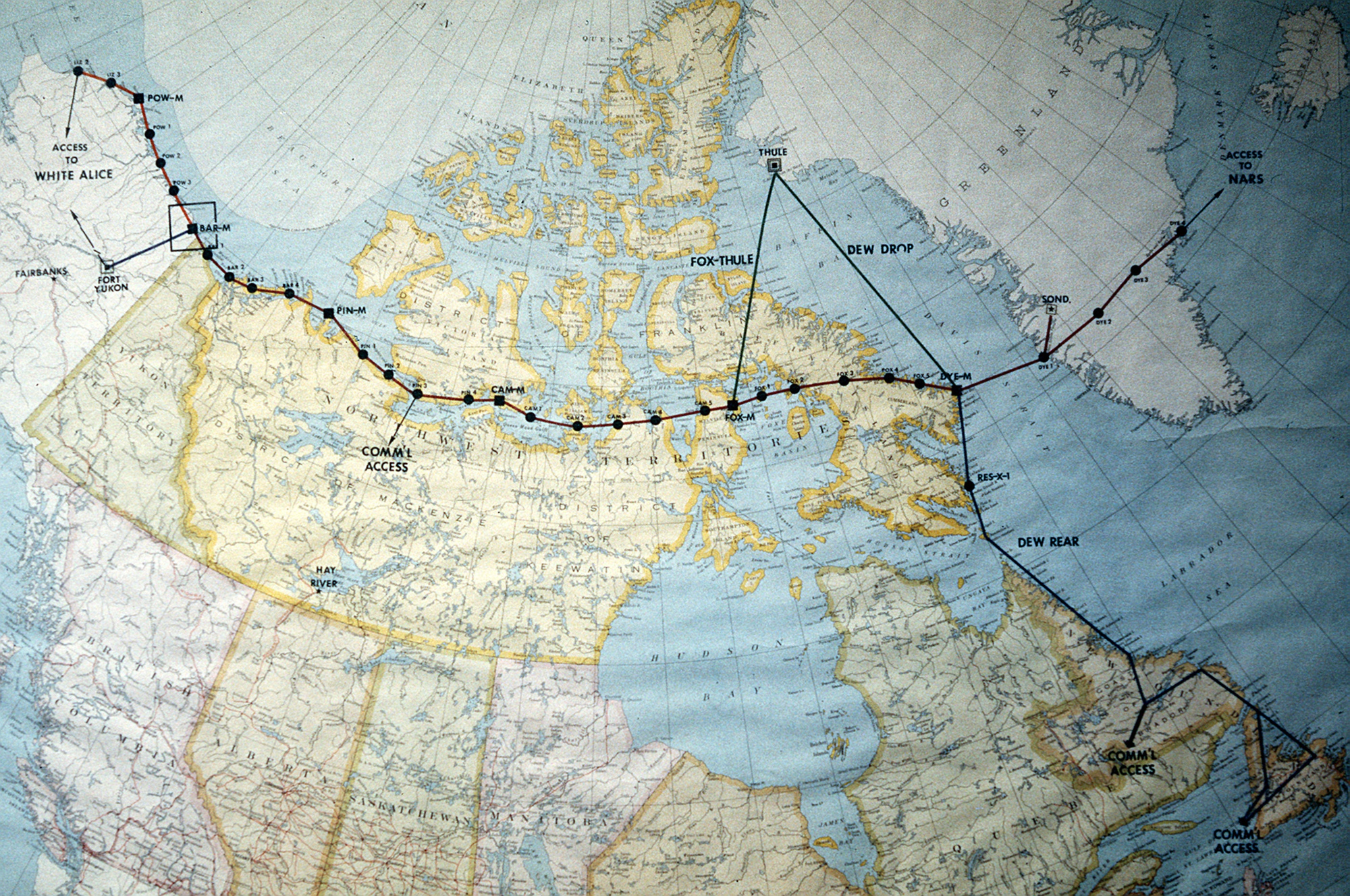
The original Arctic chain ran from Alaska across northern Canada to Cape Dyer on Baffin Island. Its main, auxiliary and intermediate stations were not all alike. Main stations were sector centers with extensive radar, communications and support facilities; auxiliary stations had rotating search radars and smaller support compounds; intermediate stations filled gaps. The two governments declared the original line operational on July 31, 1957. [2] [4]
How Warning Worked
At a radar station, the search antenna swept a sector of sky for aircraft. Automatic alerting reduced the need for operators to stare continuously at an otherwise empty display, but people still had to examine indications and pass a useful warning onward. Main and auxiliary stations carried the principal search radars. AN/FPS-23 continuous-wave equipment at intermediate locations helped detect aircraft flying through gaps, especially at lower altitude. Station reports moved through communications circuits toward air-defense command centers, where they could be combined with other information. [1] [4]
The line's communications were as consequential as its radar. MIT researchers developed ionospheric-scatter links for long-range rearward traffic, while tropospheric-scatter links carried multichannel traffic laterally between stations. Other radio, cable and eventually satellite arrangements were added or changed as the network matured. These links carried warning data and voice traffic; their antennas were communications equipment, not additional search radars. In Alaska, White Alice was a related communications system, and some radar installations housed White Alice facilities. [1] [4] [5]
A functioning sector required more than one model of radar. Power generation, heated electronics space, fuel, maintenance, communications, and aircraft or sealift access had to keep the stations available in severe weather. The DEW Line thus operated as an interdependent chain of surveillance sites, relay links and command connections rather than a row of independent dishes. [1] [4]
Life and Logistics at the Stations
Many main and auxiliary stations used connected prefabricated modules for working and living spaces. Main sites provided broader sector support; auxiliary sites had a smaller complement of facilities. Garages, warehouses, fuel tanks, generators, roads and airstrips varied by location. The buildings and equipment had to be maintained through long winters, short resupply seasons and unpredictable flying weather. [4]
Civilian technicians, pilots, mechanics, cooks and other workers sustained the line alongside military personnel. Canadian records show that Inuit workers were part of station operations, while the construction and continuing presence of the sites affected northern communities. The DEW Line brought wages and transport links, but also reshaped local life. This human history belongs beside the radar and construction story. [3]
Aleutian, Greenland and Later Changes
The original 1957 line did not cover every approach. An Aleutian extension became operational in April 1959, linking Cold Bay, Nikolski, Driftwood Bay, Cape Sarichef, Port Moller and Port Heiden. The Army Corps identifies AN/FPS-19 radar at each of those stations. That six-station extension closed in June 1969, while the northern DEW network continued operating. [5]
To the east, stations in Greenland and a link through Iceland extended the system's reach and communications. A contemporary operations handbook describes four Greenland sites, including two built on the ice cap, and describes DYE-5 in Iceland as a link to the North Atlantic radio network. Station patterns and circuits changed over time; a later map of the network therefore shows more than the original 1957 chain. [1] [4]
Technology and organization also changed within the older line. Some intermediate stations were retired, communications paths were revised, and later radar and support equipment replaced parts of the original installation. These changes kept the aircraft-warning mission alive but made the 1980s system different from the one opened in 1957. [4]
Replacement and Legacy
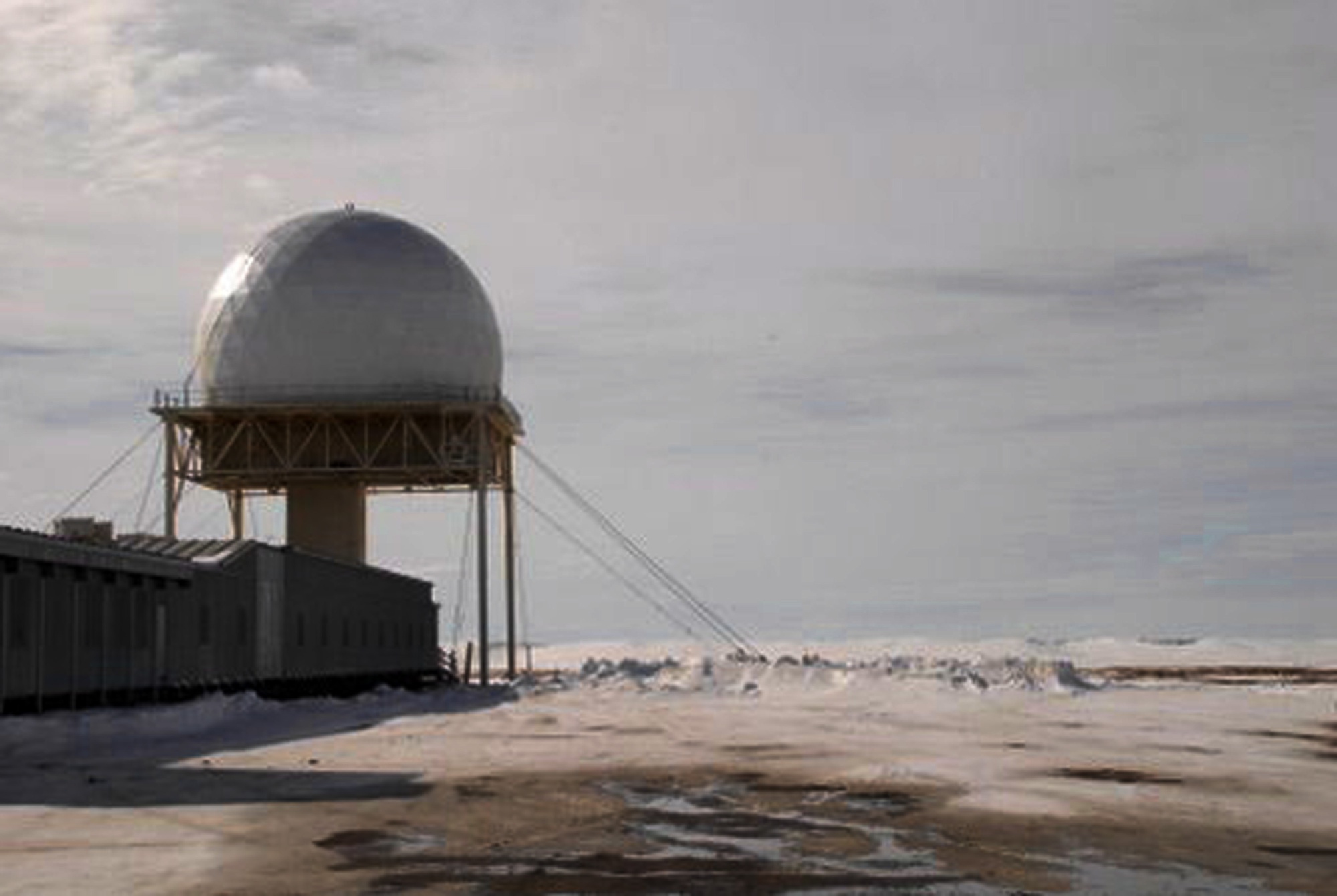
By the later Cold War, the aging DEW radar system faced mounting maintenance and performance challenges. The United States and Canada built the North Warning System between 1986 and 1992, using long- and short-range radars to continue surveillance of the northern approaches. The DEW Line was replaced as a network by 1993. A successor radar at a former DEW location does not mean the 1950s equipment survived unchanged: Barter Island, for example, continued as a North Warning System site with an AN/FPS-117. [2] [5] [7]
The DEW Line's legacy is visible in the air-defense mission, in surviving sites and in the communities affected by decades of northern military operations. Its original accomplishment was to link distant radar stations into a warning system that could function across an immense region. For individual installations and the complete station list, use the DEW Line station directory; for the radar and communications technologies, explore the AN/FPS-19, AN/FPS-117 and White Alice history pages. [1] [2] [3] [7]
Chronology
- 1952: The MIT Summer Study recommends a northern radar and communications line. [1]
- 1953-1954: Experimental work at Barter Island and other Alaska tests advances the radar design. [1] [2]
- May 1955: Canada and the United States agree on conditions for DEW stations in Canadian territory. [3]
- July 31, 1957: The original Arctic DEW Line is declared operational. [2]
- April 1959: The six-station Aleutian extension becomes operational. [5]
- 1959-1962: Greenland and Iceland links extend the eastern end of the system. [1] [4]
- June 1969: The Aleutian extension closes; the northern DEW network remains in service. [5]
- 1986-1992: The North Warning System is built across the northern approaches. [7]
- By 1993: The North Warning System replaces the DEW Line as a network. [2]
Information Sources
- MIT Lincoln Laboratory, SAGE: Semi-Automatic Ground Environment Air Defense System, DEW Line section. Read the laboratory history.
- Air Force Historical Research Agency, Space Heritage: North America's Polar Shield: The DEW Line, July 28, 2026. Read the Air Force history.
- Distant Early Warning Coordinating Committee, Minutes and Progress Reports, 1955-63, including the May 1955 Canada-U.S. agreement, compiled by P. Whitney Lackenbauer and Matthew Farish. Read the archival compilation.
- U.S. Air Force, Distant Early Warning System Operations Handbook, Capt. Pamela G. Rooney, construction, stations, communications and support sections. Read the operations handbook.
- U.S. Army Corps of Engineers, The Cold War in Alaska: A Management Plan for Cultural Resources, 1994, DEW Line and Aleutian-extension sections. Read the Corps study.
- U.S. Air Force, DEW Line map photograph DF-ST-88-03442 by Tech. Sgt. Donald L. Wetterman, February 20, 1987. View map provenance and reuse status.
- Department of National Defence Canada, North Warning System In-Service Support, January 31, 2022. Read the Canadian backgrounder.
- U.S. Air Force, Barter Island Radar Site, photograph 090427-F-1735C-148 by 1st Lt. John T. Callahan, April 27, 2009. View the Air Force photograph.
